
Shenandoah topographic map
Interactive map
Click on the map to display elevation.
About this map
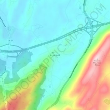
Name: Shenandoah topographic map, elevation, terrain.
Average elevation: 153 m
Minimum elevation: 76 m
Maximum elevation: 361 m
Other topographic maps
Click on a map to view its topography, its elevation and its terrain.
Stormville
United States > New York > Dutchess County > Town of East Fishkill
Stormville, Town of East Fishkill, Dutchess County, New York, 12582, United States
Average elevation: 112 m
Hopewell Junction
United States > New York > Dutchess County > Town of East Fishkill
Hopewell Junction, Town of East Fishkill, Dutchess County, New York, United States
Average elevation: 83 m