
Boßler topographic map
Interactive map
Click on the map to display elevation.
About this map
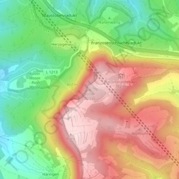
Name: Boßler topographic map, elevation, terrain.
Average elevation: 639 m
Minimum elevation: 471 m
Maximum elevation: 805 m
Auf dem Boßler befindet sich in einer Höhenlage von 785 m ein bewirtschaftetes Haus der Naturfreunde-Ortsgruppe Göppingen, das Boßlerhaus, das neben dem Gruibinger Wiesle ein beliebtes Wanderziel ist.
Other topographic maps
Click on a map to view its topography, its elevation and its terrain.
Wolfbühl
Deutschland > Baden-Württemberg > Landkreis Göppingen > Gruibingen
Wolfbühl, Gruibingen, Gemeindeverwaltungsverband Oberes Filstal, Landkreis Göppingen, Baden-Württemberg, 73344, Deutschland
Average elevation: 692 m