
Make a donation
Hanworth topographic map
Click on the map to display elevation.
Make a donation
Hanworth
The parish church of Saint Bartholomew dates from the 14th century but parts of the building date from an earlier building. On the outside north wall of the chancel , there are traces of Saxon windows. On the eastern elevation, the east window dates from between 1290 and 1350. The nave and south aisles are of a later date. The windows are Perpendicular in style and date from between 1350 and 1530, and small pieces of medieval stained glass can be seen in the top lights. The clerestory has an unusual arrangement of two windows to each arch. The tower is constructed from flint and has traceried sound holes and was built in the 15th century. The tower houses five bells. The font dates from before the present church and has a large bowl supported by four plain pillars. Hanging over the chancel arch there are the royal arms of Queen Anne (1702–1714) which were adopted by the crown after the union of England and Scotland in 1707. The church organ was built around 1865 by 'Father' Henry Willis, the famous London organ builder. It originally cost £70 and is the only miniature Father Willis organ in Norfolk.
Make a donation
About this map
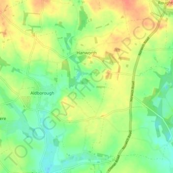
Name: Hanworth topographic map, elevation, terrain.
Location: Hanworth, North Norfolk, Norfolk, England, United Kingdom (52.84513 1.25503 52.88040 1.33146)
Average elevation: 35 m
Minimum elevation: 16 m
Maximum elevation: 55 m
Make a donation
Other topographic maps
Click on a map to view its topography, its elevation and its terrain.
Beacon Hill
United Kingdom > England > Norfolk > North Norfolk
Beacon Hill is a part of the Cromer Ridge which is a ridge of old glacial moraines (terminal moraine) that stands next to the coast above Cromer. The Cromer Ridge seems to have been the front line of the ice sheet for some time at the last glaciations, which is shown by the large size of the feature. All the…
Average elevation: 65 m
Make a donation
Make a donation
North Walsham and Dilham Canal
United Kingdom > England > Norfolk > North Norfolk > Honing
Average elevation: 21 m
Make a donation
Ridlington
United Kingdom > England > Norfolk > North Norfolk > Witton and Ridlington
Average elevation: 9 m
Make a donation
Whimpwell Green
United Kingdom > England > Norfolk > North Norfolk > Happisburgh
Average elevation: 4 m
Make a donation
Beeston Bump
United Kingdom > England > Norfolk > North Norfolk > Sheringham > Beeston Regis
Average elevation: 20 m
Make a donation
Stalham Green
United Kingdom > England > Norfolk > North Norfolk > Stalham Green
Average elevation: 5 m
Newgate
United Kingdom > England > Norfolk > North Norfolk > Cley next the Sea > Newgate
Average elevation: 22 m
Bacton Green
United Kingdom > England > Norfolk > North Norfolk > Bacton > Bacton Green
Average elevation: 9 m
West Raynham
United Kingdom > England > Norfolk > North Norfolk > West Raynham
Average elevation: 59 m
Make a donation
Sheringham Park
United Kingdom > England > Norfolk > North Norfolk > Upper Sheringham
Average elevation: 61 m
Johnson Street
United Kingdom > England > Norfolk > North Norfolk > Ludham > Johnson Street
Average elevation: 3 m
Make a donation