
Castle of Good Hope topographic map
Interactive map
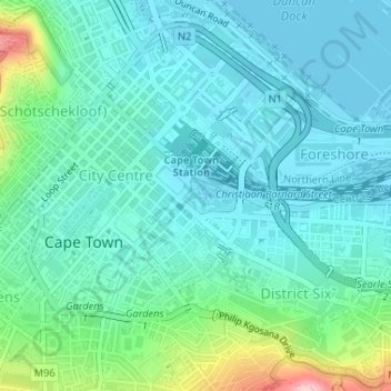
Click on the map to display elevation.
About this map
Name: Castle of Good Hope topographic map, elevation, terrain.
Average elevation: 38 m
Minimum elevation: 0 m
Maximum elevation: 189 m
Other topographic maps
Click on a map to view its topography, its elevation and its terrain.
Company Gardens Pond
South Africa > Western Cape > City of Cape Town > Cape Town
Company Gardens Pond, Cape Town Ward 115, Cape Town, City of Cape Town, Western Cape, 8001, South Africa
Average elevation: 82 m
Table Mountain
South Africa > Western Cape > City of Cape Town > Cape Town
Table Mountain, Cape Town Ward 54, Cape Town, City of Cape Town, Western Cape, 8040, South Africa
Average elevation: 583 m