
Thank you for supporting this site ❤️
Make a donation
Make a donation
Lac Flamand topographic map
Click on the map to display elevation.
Thank you for supporting this site ❤️
Make a donation
Make a donation
About this map
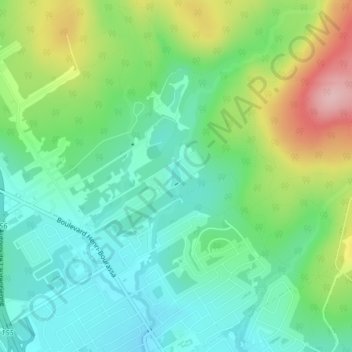
Name: Lac Flamand topographic map, elevation, terrain.
Average elevation: 210 m
Minimum elevation: 151 m
Maximum elevation: 334 m
Thank you for supporting this site ❤️
Make a donation
Make a donation
Other topographic maps
Click on a map to view its topography, its elevation and its terrain.
Thank you for supporting this site ❤️
Make a donation
Make a donation
Thank you for supporting this site ❤️
Make a donation
Make a donation
Thank you for supporting this site ❤️
Make a donation
Make a donation
Notre-Dame-des-Laurentides
Canada > Québec > Agglomération de Québec > Québec
Average elevation: 204 m
Vieux-Québec–Cap-Blanc–Colline-Parlementaire
Canada > Québec > Agglomération de Québec > Québec
Average elevation: 26 m
Thank you for supporting this site ❤️
Make a donation
Make a donation
Thank you for supporting this site ❤️
Make a donation
Make a donation
Réserve naturelle des Marais-du-Nord
Canada > Québec > Agglomération de Québec > Québec
Average elevation: 176 m
Réserve naturelle des Marais-du-Nord
Canada > Québec > Agglomération de Québec > Québec
Average elevation: 176 m
Thank you for supporting this site ❤️
Make a donation
Make a donation