
Make a donation
Gulmarg topographic map
Click on the map to display elevation.
Make a donation
Gulmarg
Gulmarg (also known as Gulmarag, lit. 'meadow of flowers' in Kashmiri) is a hill station and a notified area committee in Baramulla district of the Indian union territory of Jammu and Kashmir. It is located in the Indian administered Kashmir, close to the Line of Control that serves as the de facto border between India and Pakistan. It is in the Pir Panjal Range in the Western Himalayas within the boundaries of the Gulmarg Wildlife Sanctuary. Gulmarg is situated at an altitude of 2,650 m (8,690 ft), and is a popular tourist and skiing destination in the Kashmir Valley.
Make a donation
About this map
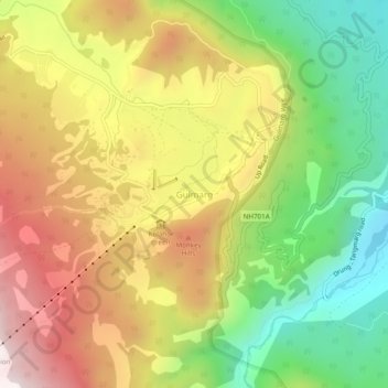
Name: Gulmarg topographic map, elevation, terrain.
Location: Gulmarg, Tangmarg, Baramulla, Jammu and Kashmir, 193403, India (34.02897 74.37212 34.06897 74.41212)
Average elevation: 2,590 m
Minimum elevation: 2,165 m
Maximum elevation: 3,047 m
Make a donation
Other topographic maps
Click on a map to view its topography, its elevation and its terrain.