
Barragem de Serra Serrada topographic map
Interactive map
Click on the map to display elevation.
About this map
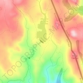
Name: Barragem de Serra Serrada topographic map, elevation, terrain.
Average elevation: 1,261 m
Minimum elevation: 1,111 m
Maximum elevation: 1,363 m
Other topographic maps
Click on a map to view its topography, its elevation and its terrain.
Portelo
Portugal > Distrito de Bragança > Bragança > França
Portelo, França, Bragança, Distrito de Bragança, Portugal
Average elevation: 869 m