
Spork topographic map
Interactive map
Click on the map to display elevation.
About this map
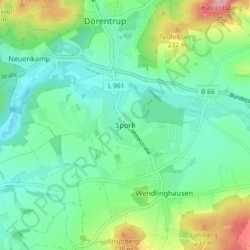
Name: Spork topographic map, elevation, terrain.
Average elevation: 163 m
Minimum elevation: 113 m
Maximum elevation: 297 m
Other topographic maps
Click on a map to view its topography, its elevation and its terrain.
Humfeld
Deutschland > Nordrhein-Westfalen > Kreis Lippe > Dörentrup
Humfeld, Betzen, Dörentrup, Kreis Lippe, Nordrhein-Westfalen, Deutschland
Average elevation: 200 m
Blomenstein
Deutschland > Nordrhein-Westfalen > Kreis Lippe > Dörentrup > Betzen
Blomenstein, Wendlinghausen, Betzen, Dörentrup, Kreis Lippe, Nordrhein-Westfalen, 32694, Deutschland
Average elevation: 192 m
Betzen
Deutschland > Nordrhein-Westfalen > Kreis Lippe > Dörentrup > Betzen
Betzen, Dörentrup, Kreis Lippe, Nordrhein-Westfalen, 32694, Deutschland
Average elevation: 179 m
Hillentrup
Deutschland > Nordrhein-Westfalen > Kreis Lippe > Dörentrup > Hillentrup
Hillentrup, Dörentrup, Kreis Lippe, Nordrhein-Westfalen, Deutschland
Average elevation: 209 m