
Make a donation
Markaba topographic map
Click on the map to display elevation.
Make a donation
About this map
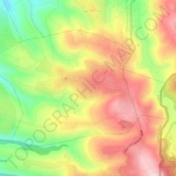
Name: Markaba topographic map, elevation, terrain.
Location: Markaba, Marjayoun District, Nabatieh Governorate, Lebanon (33.21815 35.49181 33.24452 35.53909)
Average elevation: 668 m
Minimum elevation: 453 m
Maximum elevation: 857 m
Make a donation
Other topographic maps
Click on a map to view its topography, its elevation and its terrain.
Make a donation
Make a donation
Meiss Ej Jabal
Lebanon > Nabatieh Governorate
The municipality of Mais al-Jabal is located in the Marjayoun District, one of the eight mohafazats (governorates) of Lebanon. Mais al-Jabal is 114 kilometers (70.8396 mi) away from Beyrouth (Beirut) the capital of Lebanon. Its elevation is 630 meters (2067.03 ft - 688.968 yd) above sea level. Mais al-Jabal…
Average elevation: 551 m
Aynata
Lebanon > Nabatieh Governorate
Israeli archaeologist Yohanan Aharoni identified Aynata as ancient En-hazor, and says it appears in the topographical lists of Thutmose III.
Average elevation: 753 m
Make a donation
Maroun Al Ras
Lebanon > Nabatieh Governorate
Maroun al-Ras is strategically important as it overlooks the surrounding towns. The village's elevation is 911 meters (2,989 feet).
Average elevation: 767 m
Make a donation
Make a donation
Make a donation
Kfour
Lebanon > Nabatieh Governorate
Kfour (Arabic:كفور) is a village and municipality in the Keserwan District of the Keserwan-Jbeil Governorate in Lebanon. Its average elevation is 830 metres (2723 ft) above sea level and its total land area is 426 hectares. Kfour's inhabitants are almost predominantly Maronite Catholic. As of 2008, the…
Average elevation: 404 m
Make a donation
Make a donation