
Thank you for supporting this site ❤️
Make a donation
Make a donation
Leesten topographic map
Click on the map to display elevation.
Thank you for supporting this site ❤️
Make a donation
Make a donation
Leesten
Leesten hat eine Höhe von ungefähr 300 m ü. NN. und liegt an den Staatsstraßen 2188 und 2210. 2010 wurden in Leesten 259 Einwohner gezählt.
Thank you for supporting this site ❤️
Make a donation
Make a donation
About this map
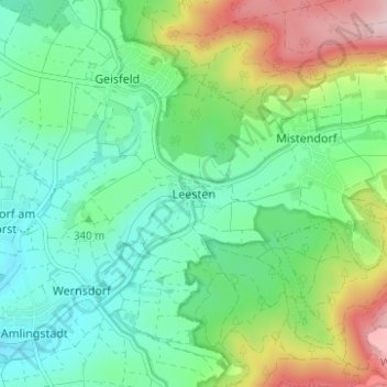
Name: Leesten topographic map, elevation, terrain.
Average elevation: 359 m
Minimum elevation: 268 m
Maximum elevation: 567 m
Thank you for supporting this site ❤️
Make a donation
Make a donation