
Thank you for supporting this site ❤️
Make a donation
Make a donation
Lupburg topographic map
Click on the map to display elevation.
Thank you for supporting this site ❤️
Make a donation
Make a donation
Lupburg
Bux | Degerndorf | Dettenhofen | Eggenthal | Fischhaus | Gottesberg | Haid | Höhenberg | Höhendorf | Lupburg | Mantlach an der Laaber | Meierhof | Neuhaid | Neuhof | Niederhofen | Pöfersdorf | Pöllenhaid | Prünthal | Rackendorf | Rammersdorf | See | Seibertshofen | Sturmmühle | Wieselbruck
Thank you for supporting this site ❤️
Make a donation
Make a donation
About this map
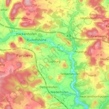
Name: Lupburg topographic map, elevation, terrain.
Average elevation: 508 m
Minimum elevation: 422 m
Maximum elevation: 597 m
Thank you for supporting this site ❤️
Make a donation
Make a donation