
Make a donation
Jiuquan topographic map
Click on the map to display elevation.
Make a donation
About this map
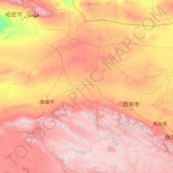
Name: Jiuquan topographic map, elevation, terrain.
Location: Jiuquan, Gansu, 735000, China (38.14495 92.33865 42.79457 100.24063)
Average elevation: 2,146 m
Minimum elevation: 177 m
Maximum elevation: 5,663 m
Make a donation
Other topographic maps
Click on a map to view its topography, its elevation and its terrain.
Junma Sichang Qilian
China > Gansu > Shandan County > Shandan horse breeding area
Average elevation: 2,558 m
Zhangye Danxia National Geological Park
China > Gansu > Linze County > Nantai
Average elevation: 1,759 m
Mount Qilian
China > Gansu > Sunan Yugur Autonomous County > Qifeng Tibetan Ethnic Township
Average elevation: 5,071 m
Make a donation
Make a donation
Make a donation
Make a donation
Make a donation
Make a donation
Gannan
China > Gansu > Hezuo City > Tongqin
Gannan, as illustrated by this chart for Xiahe, has an alpine subarctic climate (Köppen Dwc) that grades into an alpine climate (ETH) at the highest elevations. The climate is characterised by mild, rainy summers and frigid, but dry and sunny, winters.
Average elevation: 3,075 m
Make a donation
Make a donation
Baiyin
Baiyin is part loess plateau, part desert. Elevation ranges from 1,275 to 3,321 meters (4,183 to 10,896 feet) above sea-level. The climate is very arid with only 110–352 mm (4.3–13.9 in) of annual precipitation. Annual evaporation is 2,101 mm (82.7 in) resulting in a net loss of approximately 1,800 mm (71…
Average elevation: 1,836 m
Make a donation