
Make a donation
Gorham topographic map
Click on the map to display elevation.
Make a donation
Gorham
The highest point in Gorham is along its western border, on a spur of Mount Madison, where the elevation reaches 3,030 feet (920 m) above sea level. While Gorham itself is surrounded by larger mountains, a small prominent peak within the town is 2,400-foot (730 m) high Pine Mountain.
Make a donation
About this map
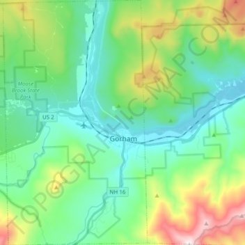
Name: Gorham topographic map, elevation, terrain.
Location: Gorham, Coös County, New Hampshire, 03581, United States (44.33998 -71.24869 44.44987 -71.15793)
Average elevation: 477 m
Minimum elevation: 215 m
Maximum elevation: 1,214 m
Make a donation
Other topographic maps
Click on a map to view its topography, its elevation and its terrain.
Mount Washington
United States > New Hampshire > Coos County
Mount Washington, in New Hampshire, is the highest peak in the Northeastern United States at 6,288.2 ft (1,916.6 m) and the most topographically prominent mountain east of the Mississippi River.
Average elevation: 1,568 m
Mount Washington
United States > New Hampshire > Coos County
Mount Washington, also known as Agiocochook, is an ultra-prominent mountain in the state of New Hampshire. It is the highest peak in the Northeastern United States at 6,288.2 ft (1,916.6 m) and the most topographically prominent mountain east of the Mississippi River.
Average elevation: 1,568 m
Mount Adams
United States > New Hampshire > Coos County
Mount Adams, elevation 5,793 feet (1,766 m) above sea level, is a mountain in New Hampshire, the second highest peak in the Northeast United States after its nearby neighbor, Mount Washington. Located in the northern Presidential Range, Mount Adams was named after John Adams, the second President of the United…
Average elevation: 1,379 m
Make a donation
Mount Washington
United States > New Hampshire > Coos County
Mount Washington is an ultra-prominent mountain in the state of New Hampshire. It is the highest peak in the Northeastern United States at 6,288.2 ft (1,916.6 m) and the most topographically prominent mountain east of the Mississippi River.
Average elevation: 1,568 m
Make a donation
Make a donation
Mount Washington
United States > New Hampshire > Coos County
Mount Washington, also known as Agiocochook, is an ultra-prominent mountain in the state of New Hampshire. It is the highest peak in the Northeastern United States at 6,288.2 ft (1,916.6 m) and the most topographically prominent mountain east of the Mississippi River.
Average elevation: 1,568 m
Make a donation
Make a donation