
Groton topographic map
Interactive map
Click on the map to display elevation.
About this map
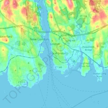
Name: Groton topographic map, elevation, terrain.
Location: Groton, New London County, Connecticut, United States (41.27661 -72.09722 41.40041 -71.95912)
Average elevation: 21 m
Minimum elevation: -4 m
Maximum elevation: 111 m
Other topographic maps
Click on a map to view its topography, its elevation and its terrain.
Long Hill
United States > Connecticut > Groton
Long Hill, Groton, New London County, Connecticut, 06340, United States
Average elevation: 30 m