
Couète topographic map
Interactive map
Click on the map to display elevation.
About this map
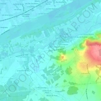
Name: Couète topographic map, elevation, terrain.
Average elevation: 45 m
Minimum elevation: 29 m
Maximum elevation: 119 m
Other topographic maps
Click on a map to view its topography, its elevation and its terrain.
Jardin du Curé
France > Centre-Val de Loire > Indre-et-Loire > Huismes
Jardin du Curé, Le Bourg, Huismes, Chinon, Indre-et-Loire, Centre-Val de Loire, France métropolitaine, 37420, France
Average elevation: 67 m
Les Places
France > Centre-Val de Loire > Indre-et-Loire > Huismes
Les Places, Huismes, Chinon, Indre-et-Loire, Centre-Val de Loire, France métropolitaine, 37420, France
Average elevation: 48 m