
Le Colombier topographic map
Interactive map
Click on the map to display elevation.
About this map
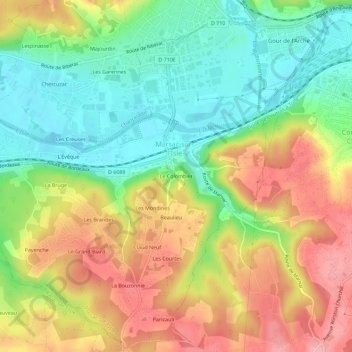
Name: Le Colombier topographic map, elevation, terrain.
Average elevation: 131 m
Minimum elevation: 72 m
Maximum elevation: 201 m
Other topographic maps
Click on a map to view its topography, its elevation and its terrain.
La Bouzonnie
France > Nouvelle-Aquitaine > Dordogne > Marsac-sur-l'Isle
La Bouzonnie, Marsac-sur-l'Isle, Périgueux, Dordogne, Nouvelle-Aquitaine, France métropolitaine, 24430, France
Average elevation: 143 m