
Thank you for supporting this site ❤️
Make a donation
Make a donation
Lac Grenier topographic map
Click on the map to display elevation.
Thank you for supporting this site ❤️
Make a donation
Make a donation
About this map
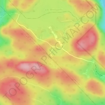
Name: Lac Grenier topographic map, elevation, terrain.
Location: Lac Grenier, Shawinigan, Mauricie, Québec, Canada (46.65263 -72.87536 46.65320 -72.87497)
Average elevation: 275 m
Minimum elevation: 175 m
Maximum elevation: 339 m
Thank you for supporting this site ❤️
Make a donation
Make a donation
Other topographic maps
Click on a map to view its topography, its elevation and its terrain.
Lac Wapizagonke
Canada > Québec > Shawinigan
D'une longueur de 15 km, le lac Wapizagonke est situé à l'extrémité ouest du parc national de la Mauricie, au nord de Shawinigan, dans le canton de Désaulniers. Ce lac est d'une forme étroite et tout en longueur dans l'axe nord-sud. Son embouchure se déverse par son extrémité sud dans la rivière…
Average elevation: 335 m
Thank you for supporting this site ❤️
Make a donation
Make a donation
Thank you for supporting this site ❤️
Make a donation
Make a donation