
Geraberg topographic map
Interactive map
Click on the map to display elevation.
About this map
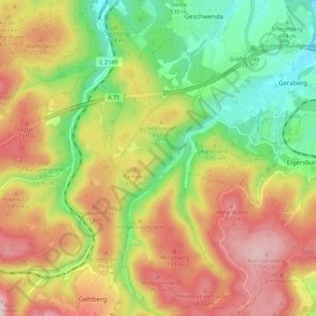
Name: Geraberg topographic map, elevation, terrain.
Location: Geraberg, Geratal, Ilm-Kreis, Thüringen, 99331, Deutschland (50.67574 10.79153 50.73422 10.86940)
Average elevation: 604 m
Minimum elevation: 406 m
Maximum elevation: 826 m
Geraberg liegt im Tal der Zahmen Gera an der Einmündung des Körnbachs in etwa 450 Metern Höhe. Südwestlich des Ortes beginnt der Thüringer Wald. Nördlich des Ortes liegt der 496 Meter hohe Geschwendaer Berg, südlich grenzt Geraberg direkt an Elgersburg.
Other topographic maps
Click on a map to view its topography, its elevation and its terrain.
Gräfenroda
Deutschland > Thüringen > Ilm-Kreis > Geratal > Gräfenroda
Gräfenroda, Geratal, Ilm-Kreis, Thüringen, 99330, Deutschland
Average elevation: 568 m