
New Britain topographic map
Interactive map
Click on the map to display elevation.
About this map
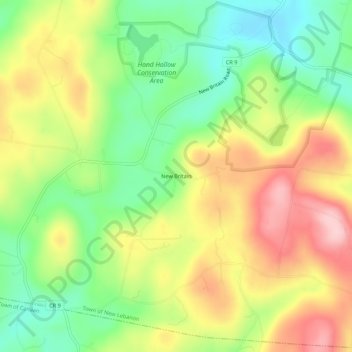
Name: New Britain topographic map, elevation, terrain.
Average elevation: 311 m
Minimum elevation: 217 m
Maximum elevation: 421 m
Other topographic maps
Click on a map to view its topography, its elevation and its terrain.
Lebanon Springs
United States > New York > Columbia County > Town of New Lebanon
Lebanon Springs, Town of New Lebanon, Columbia County, New York, 12125, United States
Average elevation: 314 m
West Lebanon
United States > New York > Columbia County > Town of New Lebanon
West Lebanon, Town of New Lebanon, Columbia County, New York, 12195, United States
Average elevation: 243 m
New Lebanon Center
United States > New York > Columbia County > Town of New Lebanon
New Lebanon Center, Town of New Lebanon, Columbia County, New York, 12125, United States
Average elevation: 284 m