
Elizaville topographic map
Interactive map
Click on the map to display elevation.
About this map
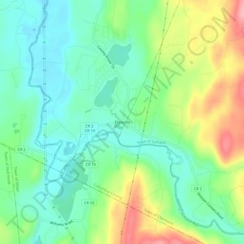
Name: Elizaville topographic map, elevation, terrain.
Average elevation: 105 m
Minimum elevation: 58 m
Maximum elevation: 195 m
Other topographic maps
Click on a map to view its topography, its elevation and its terrain.
Blue Stores
United States > New York > Columbia County > Town of Livingston
Blue Stores, Town of Livingston, Columbia County, New York, 12526, United States
Average elevation: 63 m
Burden
United States > New York > Columbia County > Town of Livingston
Burden, Town of Livingston, Columbia County, New York, United States
Average elevation: 60 m
Linlithgo Mills
United States > New York > Columbia County > Town of Livingston
Linlithgo Mills, Town of Livingston, Columbia County, New York, 12541, United States
Average elevation: 76 m
Linlithgo
United States > New York > Columbia County > Town of Livingston
Linlithgo, Town of Livingston, Columbia County, New York, United States
Average elevation: 49 m