
Make a donation
Kellogg topographic map
Click on the map to display elevation.
Make a donation
Kellogg
Kellogg is located at 47°32′18″N 116°07′31″W / 47.53833°N 116.12528°W / 47.53833; -116.12528 (47.538391, -116.125406), at an elevation of 2,303 feet (702 m) above sea level.
Make a donation
About this map
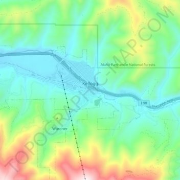
Name: Kellogg topographic map, elevation, terrain.
Location: Kellogg, Shoshone County, Idaho, 83837, United States (47.52081 -116.18408 47.55095 -116.09384)
Average elevation: 939 m
Minimum elevation: 682 m
Maximum elevation: 1,596 m
Make a donation
Other topographic maps
Click on a map to view its topography, its elevation and its terrain.
Burke
United States > Idaho > Shoshone County > Mace
Burke is located about 7 miles (11 km) northeast of Wallace, at an elevation of 3,700 feet (1,130 m) above sea level. It is accessed from Wallace on Burke-Canyon Creek Road (State Highway 4). The town is located approximately 100 miles (160 km) south of the Canadian province of British Columbia, and roughly 5…
Average elevation: 1,459 m
Make a donation
Make a donation
Make a donation