
Make a donation
Lockwood Peak topographic map
Click on the map to display elevation.
Make a donation
About this map
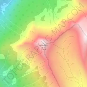
Name: Lockwood Peak topographic map, elevation, terrain.
Average elevation: 2,225 m
Minimum elevation: 1,477 m
Maximum elevation: 2,884 m
Make a donation
Other topographic maps
Click on a map to view its topography, its elevation and its terrain.
Whiteswan Lake
Canada > British Columbia > Regional District of East Kootenay > Area F (Columbia Lake/Windermere Lake)
Average elevation: 1,392 m
Windermere Lake
Canada > British Columbia > Regional District of East Kootenay > Area F (Columbia Lake/Windermere Lake) > Windermere
Average elevation: 1,010 m
Findlay Creek
Canada > British Columbia > Regional District of East Kootenay > Area F (Columbia Lake/Windermere Lake)
Average elevation: 1,270 m
Whiteswan Lake Provincial Park
Canada > British Columbia > Regional District of East Kootenay > Area F (Columbia Lake/Windermere Lake)
Average elevation: 1,667 m
Make a donation
Columbia Lake
Canada > British Columbia > Regional District of East Kootenay > Area F (Columbia Lake/Windermere Lake)
Average elevation: 1,249 m