
Thank you for supporting this site ❤️
Make a donation
Make a donation
Wasserlos topographic map
Click on the map to display elevation.
Thank you for supporting this site ❤️
Make a donation
Make a donation
About this map
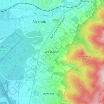
Name: Wasserlos topographic map, elevation, terrain.
Average elevation: 185 m
Minimum elevation: 107 m
Maximum elevation: 404 m
Thank you for supporting this site ❤️
Make a donation
Make a donation
Other topographic maps
Click on a map to view its topography, its elevation and its terrain.
Thank you for supporting this site ❤️
Make a donation
Make a donation
Weisserstein
Germany > Bavaria > Landkreis Aschaffenburg > Rothenbucher Forst
Average elevation: 429 m