
Make a donation
Vilhena topographic map
Click on the map to display elevation.
Make a donation
Vilhena
The climate is a transition between equatorial and tropical, hot and humid, with some short periods of cool weather from May to September, when the minimum temperature can reach 7 °C in the coolest days, but normally it stays around 12-16 °C. The rainy season runs from October to April. The average annual temperature is approximately 23 °C, with maximum temperature average around 30-32 °C. On the hottest days, the temperature may reach 36 °C. The annual rainfall varies from 1800 to 2400mm. The high altitude in comparison with the region average (Vilhena is situated 615m above sea level, while other cities of the state are, as a general rule, around 100-200m above it) provides constant refreshing winds, mainly during the night, keeping the temperature pleasant.
Make a donation
About this map
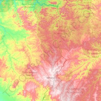
Name: Vilhena topographic map, elevation, terrain.
Average elevation: 358 m
Minimum elevation: 163 m
Maximum elevation: 631 m
Make a donation
Other topographic maps
Click on a map to view its topography, its elevation and its terrain.