
Thank you for supporting this site ❤️
Make a donation
Make a donation
Coutelant topographic map
Click on the map to display elevation.
Thank you for supporting this site ❤️
Make a donation
Make a donation
About this map
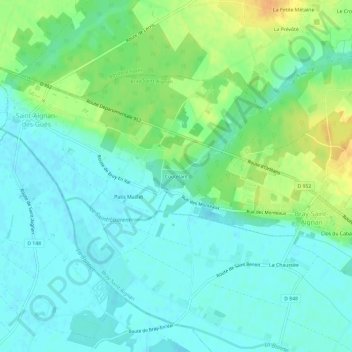
Name: Coutelant topographic map, elevation, terrain.
Average elevation: 119 m
Minimum elevation: 108 m
Maximum elevation: 142 m
Thank you for supporting this site ❤️
Make a donation
Make a donation
Other topographic maps
Click on a map to view its topography, its elevation and its terrain.
Bray-en-Val
France > Centre-Val de Loire > Loiret > Bray-Saint-Aignan
La ZNIEFF, de deuxième génération et de type 1, dénommée « Aulnaie marécageuse de Gué-bord », d'une superficie de 9 hectares, se localise entre la RD 95 et le hameau de Gué-Bord, au sud-est du bourg de Bouzy-la-Forêt, à 1,5 km de Bray-en-Val. Son altitude varie entre 115 et 120 m. Il s'agit d'une…
Average elevation: 124 m
45460
France > Centre-Val de Loire > Loiret > Bray-Saint-Aignan > Vagues du Buisson Génois-Sud
Average elevation: 129 m