
Hauppauge topographic map
Interactive map
Click on the map to display elevation.
About this map
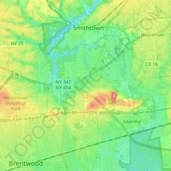
Name: Hauppauge topographic map, elevation, terrain.
Average elevation: 28 m
Minimum elevation: 1 m
Maximum elevation: 81 m
Other topographic maps
Click on a map to view its topography, its elevation and its terrain.
Village of Nissequogue
United States > New York > Suffolk County > Town of Smithtown
Village of Nissequogue, Town of Smithtown, Suffolk County, New York, United States
Average elevation: 19 m
Saint James
United States > New York > Suffolk County > Town of Smithtown
Saint James, Town of Smithtown, Suffolk County, New York, 11780, United States
Average elevation: 39 m
East Hauppauge
United States > New York > Suffolk County > Town of Smithtown > Nesconset > East Hauppauge
East Hauppauge, Nesconset, Town of Smithtown, Suffolk County, New York, 11767, United States
Average elevation: 28 m
Sunken Meadow State Park
United States > New York > Suffolk County > Town of Smithtown > Kings Park
Sunken Meadow State Park, Kings Park, Town of Smithtown, Suffolk County, New York, United States
Average elevation: 27 m
Nesconset
United States > New York > Suffolk County > Town of Smithtown
Nesconset, Town of Smithtown, Suffolk County, New York, 11767, United States
Average elevation: 31 m