
West topographic map
Interactive map
Click on the map to display elevation.
About this map
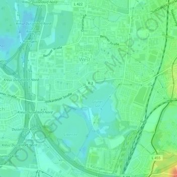
Name: West topographic map, elevation, terrain.
Average elevation: 42 m
Minimum elevation: 31 m
Maximum elevation: 72 m
Other topographic maps
Click on a map to view its topography, its elevation and its terrain.
Eggerscheidt
Deutschland > Nordrhein-Westfalen > Ratingen
Eggerscheidt, Hösel/Eggerscheidt, Ratingen, Kreis Mettmann, Nordrhein-Westfalen, Deutschland
Average elevation: 94 m
Zentrum
Deutschland > Nordrhein-Westfalen > Ratingen
Zentrum, Mitte, Ratingen, Kreis Mettmann, Regierungsbezirk Düsseldorf, Nordrhein-Westfalen, 40878, Deutschland
Average elevation: 63 m
Hülsenberg
Deutschland > Nordrhein-Westfalen > Ratingen
Hülsenberg, Ratingen, Kreis Mettmann, Regierungsbezirk Düsseldorf, Nordrhein-Westfalen, 40885, Deutschland
Average elevation: 67 m
Schloss Landsberg
Deutschland > Nordrhein-Westfalen > Ratingen
Schloss Landsberg, 1, Schloß Landsberg, Breitscheid, Lintorf/Breitscheid, Ratingen, Kreis Mettmann, Regierungsbezirk Düsseldorf, Nordrhein-Westfalen, 40885, Deutschland
Average elevation: 81 m