
Nichols topographic map
Interactive map
Click on the map to display elevation.
About this map
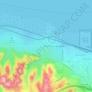
Name: Nichols topographic map, elevation, terrain.
Average elevation: 38 m
Minimum elevation: -2 m
Maximum elevation: 183 m
Other topographic maps
Click on a map to view its topography, its elevation and its terrain.
McAvoy
United States > California > Contra Costa County > Bay Point
McAvoy, Bay Point, Contra Costa County, California, United States
Average elevation: 20 m
Shore Acres
United States > California > Contra Costa County > Bay Point
Shore Acres, Bay Point, Contra Costa County, CAL Fire Northern Region, California, United States
Average elevation: 31 m