
Parry Sound topographic map
Interactive map
Click on the map to display elevation.
About this map
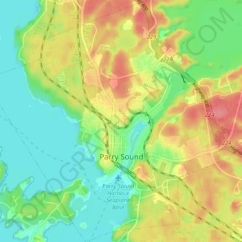
Name: Parry Sound topographic map, elevation, terrain.
Average elevation: 202 m
Minimum elevation: 171 m
Maximum elevation: 242 m
Other topographic maps
Click on a map to view its topography, its elevation and its terrain.
Baie Georgienne
Canada > Ontario > Parry Sound District > Carling Township
Baie Georgienne, Carling Township, Parry Sound District, Central Ontario, Ontario, Canada
Average elevation: 175 m
Groom Lake
Canada > Ontario > Parry Sound District > Kearney
Groom Lake, Kearney, Parry Sound District, Central Ontario, Ontario, Canada
Average elevation: 378 m