
Kohgiluye and Buyer Ahmad Province topographic map
Interactive map
Click on the map to display elevation.
Kohgiluye and Buyer Ahmad Province
The mountain range of Dena, which reaches an elevation of 4,000 metres, is located in the province, and is covered with oak forests. Another mountain is Khamin or Khami, which is located in Gachsaran country.
About this map
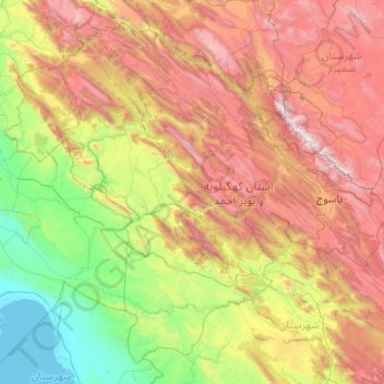
Name: Kohgiluye and Buyer Ahmad Province topographic map, elevation, terrain.
Location: Kohgiluye and Buyer Ahmad Province, Iran (29.92456 49.88621 31.48157 51.88824)
Average elevation: 1,418 m
Minimum elevation: -1 m
Maximum elevation: 4,368 m
Other topographic maps
Click on a map to view its topography, its elevation and its terrain.
Tabriz
Iran > East Azerbaijan Province > Tabriz County > Tabriz
Tabriz (Persian: تبریز (listen); Azerbaijani: تبریز) is the most populated city in northwestern Iran, one of the historical capitals of Iran and the present capital of East Azerbaijan province. It is the sixth most populous city in Iran. Located in the Quru River valley, in Iran's historic…
Average elevation: 1,594 m