
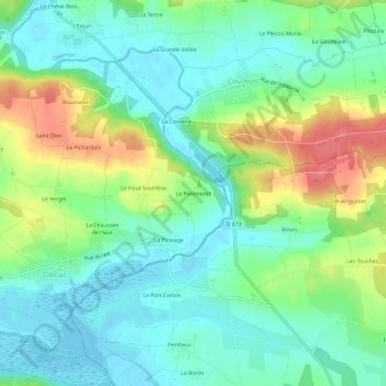
Le Pommeret topographic map
Interactive map
Click on the map to display elevation.
About this map
Name: Le Pommeret topographic map, elevation, terrain.
Average elevation: 26 m
Minimum elevation: -2 m
Maximum elevation: 79 m
Other topographic maps
Click on a map to view its topography, its elevation and its terrain.
Glénac
France > Bretagne > Morbihan > La Gacilly
Glénac, La Gacilly, Vannes, Morbihan, Bretagne, France métropolitaine, 56200, France
Average elevation: 31 m
La Moraie
France > Bretagne > Morbihan > La Gacilly
La Moraie, La Chapelle-Gaceline, La Gacilly, Vannes, Morbihan, Bretagne, France métropolitaine, 56200, France
Average elevation: 27 m
La Gacilly
France > Bretagne > Morbihan > La Gacilly
La Gacilly, Vannes, Morbihan, Bretagne, France métropolitaine, 56200, France
Average elevation: 41 m
La Glouzie
France > Bretagne > Morbihan > La Gacilly
La Glouzie, La Gacilly, Vannes, Morbihan, Bretagne, France métropolitaine, 56200, France
Average elevation: 38 m
Gazeau
France > Bretagne > Morbihan > La Gacilly
Gazeau, La Gacilly, Vannes, Morbihan, Bretagne, France métropolitaine, 56200, France
Average elevation: 36 m