
Tebet Timur topographic map
Interactive map
Click on the map to display elevation.
About this map
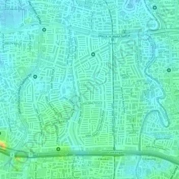
Name: Tebet Timur topographic map, elevation, terrain.
Average elevation: 20 m
Minimum elevation: 12 m
Maximum elevation: 42 m
Other topographic maps
Click on a map to view its topography, its elevation and its terrain.
RW 05
Indonesia > Jakarta Special Capital Region > Tebet Timur
RW 05, Tebet Timur, Tebet, South Jakarta, Jakarta Special Capital Region, 12820, Indonesia
Average elevation: 20 m