
Thank you for supporting this site ❤️
Make a donation
Make a donation
Rödlas topographic map
Click on the map to display elevation.
Thank you for supporting this site ❤️
Make a donation
Make a donation
Rödlas
Das Kirchdorf im Nordwesten der Gräfenberger Flächenalb liegt etwa viereinhalb Kilometer ostnordöstlich des Ortszentrums von Neunkirchen am Brand auf einer Höhe von 390 m ü. NHN.
Thank you for supporting this site ❤️
Make a donation
Make a donation
About this map
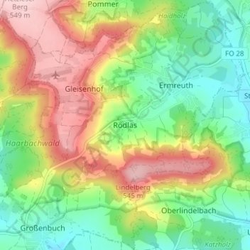
Name: Rödlas topographic map, elevation, terrain.
Average elevation: 430 m
Minimum elevation: 342 m
Maximum elevation: 549 m
Thank you for supporting this site ❤️
Make a donation
Make a donation