
Make a donation
Garbeck topographic map
Click on the map to display elevation.
Make a donation
Garbeck
Die Ortschaft Garbeck liegt im Südwesten der Stadt Balve im Märkischen Kreis. Im Südwesten bis Norden ist das Dorf von den Bergen des Sauerlandes umgeben, auf denen dichte Nadel- und Laubwälder liegen. Der 546,2 m ü. NHN hohe Gipfel des Balver Waldes, der den höchsten Punkt des Höhenzuges Iserlohner Höhe darstellt, liegt etwas mehr als 4 km nördlich des Ortes. Das Dorf selbst liegt auf 260 bis 300 Meter Höhe.
Make a donation
About this map
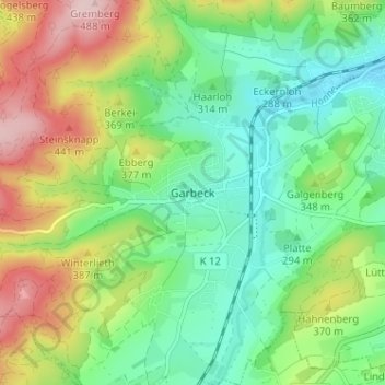
Name: Garbeck topographic map, elevation, terrain.
Average elevation: 328 m
Minimum elevation: 238 m
Maximum elevation: 491 m
Make a donation
Other topographic maps
Click on a map to view its topography, its elevation and its terrain.
Iserlohn
Deutschland > Nordrhein-Westfalen > Märkischer Kreis
Das Stadtgebiet wird im Westen auf einer Länge von 7,2 km von der Lenne durchquert und von der Ruhr im Norden zum Kreis Unna hin begrenzt, die eine Länge von 7,5 km im Stadtgebiet aufweist. Wichtige Bäche sind der Grüner Bach, der in die Lenne fließt, und der Baarbach, der im Norden in die Ruhr mündet.…
Average elevation: 251 m
Meinerzhagen
Deutschland > Nordrhein-Westfalen > Märkischer Kreis
Die höchste Erhebung im Stadtgebiet liegt mit 652 m Höhe nahe der Nordhelle bei Valbert. Die Nordhelle ist die höchste Erhebung im Märkischen Kreis. Der niedrigste Punkt im Stadtgebiet liegt mit 313 m in der Ortschaft Niederbadinghagen.
Average elevation: 419 m
Kierspe
Deutschland > Nordrhein-Westfalen > Märkischer Kreis
Die Stadt Kierspe ist eine Flächengemeinde im südwestlichen Westfalen in der Grenzlage zwischen dem Bergischen Land und dem Sauerland. Durch die auseinandergezogene Lage des Ortes entlang der B 54, B 237 und der L 528 und aufgrund der Topografie ergibt sich eine städtebaulich ungünstige Ausgangssituation…
Average elevation: 408 m
Lüdenscheid
Deutschland > Nordrhein-Westfalen > Märkischer Kreis
Lüdenscheid liegt im nordwestlichen Sauerland auf einer Höhe von 232–539 Metern, geographisch gesehen in der flachen, westsüdwest-ostnordost-gerichteten Lüdenscheider Mulde. Sie besitzt ihren Kernbereich in der Quellmulde der Rahmede und stellt einen Sattel der Wasserscheide zwischen Lenne und Volme dar,…
Average elevation: 384 m
Make a donation
Werdohl
Deutschland > Nordrhein-Westfalen > Märkischer Kreis
Mesolithische Steinwerkzeuge (Mittelsteinzeit) aus Feuerstein und Kieselschiefer wurden auf den Höhenzügen von Werdohl um Dösseln und Brenge gefunden. Die Funde sind damit älter als 7000 Jahre. Aus der Jungsteinzeit wurden Steinwerkzeuge entdeckt, die geschliffen waren. Man geht daher davon aus, dass…
Average elevation: 332 m
Herscheid
Deutschland > Nordrhein-Westfalen > Märkischer Kreis
Im Nordwesten fließt die Schwarze Ahe, die in Werdohl-Altenmühle in die Verse mündet. Leicht außerhalb des Herscheider Zentrums fließt der Bruchbach, der im Naturschutzgebiet „Auf dem Roten Schlote“ entspringt, östlich vom Zentrum in die Weiße Ahe mündet und in Hüinghausen in die Else fließt.…
Average elevation: 441 m
Balve
Deutschland > Nordrhein-Westfalen > Märkischer Kreis
Die Stadt liegt am Fuß des Balver Waldes im Naturpark Sauerland-Rothaargebirge, unweit des Sorpesees, einer Talsperre im Hochsauerlandkreis. Der Höhenzug Iserlohner Höhe im Nordwesten grenzt an die Stadtgebiete von Hemer, Menden, Iserlohn, Neuenrade, Sundern und Arnsberg. Nach Osten wird das Stadtgebiet…
Average elevation: 329 m
Hemer
Deutschland > Nordrhein-Westfalen > Märkischer Kreis
Hemer liegt in einer von ausgedehnten Wäldern bestimmten Mittelgebirgslandschaft im Nordwesten des Sauerlandes und damit im Norden der Mittelgebirgsschwelle. Die Stadt liegt zwischen dem Ruhrtal im Norden und dem Lennetal im Süden, östlich von Iserlohn. Das Stadtgebiet bildet die südöstliche Grenze der…
Average elevation: 326 m
Make a donation
Plettenberg
Deutschland > Nordrhein-Westfalen > Märkischer Kreis
Die ehemalige Gemeinde Ohle (2.981 Einwohner) und weitere Ortschaften von Plettenberg wie Böddinghausen, Bremcke, Eiringhausen (5.892 Einwohner), Elhausen, Eschen (3.045 Einwohner), Frehlinghausen, Grimminghausen, Himmelmert, Holthausen/oberes Elsetal (4.033 Einwohner) Köbbinghausen, Kückelheim, Lettmecke,…
Average elevation: 378 m
Nachrodt-Wiblingwerde
Deutschland > Nordrhein-Westfalen > Märkischer Kreis
Nachrodt-Wiblingwerde ist eine Gemeinde in Nordrhein-Westfalen, Deutschland. Sie liegt im Sauerland und gehört zum Märkischen Kreis. Weite Flächen auf den Höhen des Lennegebirges und das enge Tal der Lenne prägen das Gemeindegebiet. Im frühen 19. Jahrhundert begannen sich im derzeitigen Gemeindegebiet…
Average elevation: 319 m
Halver
Deutschland > Nordrhein-Westfalen > Märkischer Kreis
Halver liegt im westlichen märkischen Sauerland an der Grenze zwischen dem Rheinland und Westfalen, etwa 10 Kilometer westlich von Lüdenscheid. Der Hauptort befindet sich auf einer Bergkuppe mit einer Höhenlage von 374 m ü. NN (Bolsenbachtal) bis 420 m ü. NN (südliches Stadtgebiet). Der tiefste Punkt im…
Average elevation: 365 m
Neuenrade
Deutschland > Nordrhein-Westfalen > Märkischer Kreis
Neuenrade liegt im Osten des Märkischen Kreises an der Grenze zum Hochsauerland im oberen Tal der Hönne und ihres Nebenflusses Borke. Die Hönne entspringt im Westen von Neuenrade an der Südflanke des Großen Attigs (512 m). Sie fließt in nordöstlicher Richtung durch das Stadtgebiet und verlässt es…
Average elevation: 350 m
Make a donation
Altena
Deutschland > Nordrhein-Westfalen > Märkischer Kreis
Schriftliche Hinweise auf einen Betraum oder eine Betstube (jiddisch: shtibel) stammen von einem Bürgermeister der Stadt namens Trompeter. Demnach gab es an einem heute unbekannten Ort 1778 einen solchen Betraum. Ebenfalls unbekannt ist bisher der Standort der ersten Synagoge, welche 1808 gekauft wurde,…
Average elevation: 347 m
Schalksmühle
Deutschland > Nordrhein-Westfalen > Märkischer Kreis
Das Gemeindegebiet gehört zum Naturpark Sauerland-Rothaargebirge. Flächen außerhalb der bebauten Ortsteile und des Geltungsbereichs eines Bebauungsplans sind als Landschaftsschutzgebiet ausgewiesen worden, sofern kein höherer Schutzstatus wie beispielsweise Naturschutzgebiet (NSG) besteht. Im Stadtgebiet…
Average elevation: 345 m
Menden (Sauerland)
Deutschland > Nordrhein-Westfalen > Märkischer Kreis
Das Mendener Stadtgebiet gehört zum Niedersauerland, das in die Mendener Platte im Westen, den Luerwald im Osten und die Fröndenberger-Schwerter Ruhraue im Norden unterteilt ist. Das spiegelt sich auch in den Geländehöhen wider. Die Ruhr im Norden erreicht das Stadtgebiet auf einer Höhe von 130 m ü. NN…
Average elevation: 205 m
Make a donation
Hunswinkel
Deutschland > Nordrhein-Westfalen > Märkischer Kreis > Meinerzhagen
Average elevation: 378 m
Make a donation
Werkshagen
Deutschland > Nordrhein-Westfalen > Märkischer Kreis > Meinerzhagen
Average elevation: 482 m
58540
Deutschland > Nordrhein-Westfalen > Märkischer Kreis > Meinerzhagen > Blomberg
Average elevation: 433 m
Sundhellen
Deutschland > Nordrhein-Westfalen > Märkischer Kreis > Meinerzhagen
Average elevation: 401 m
Make a donation
58708
Deutschland > Nordrhein-Westfalen > Märkischer Kreis > Menden (Sauerland) > Oberoesbern
Average elevation: 222 m
Rölvedermühle
Deutschland > Nordrhein-Westfalen > Märkischer Kreis > Schalksmühle > Everinghausen
Average elevation: 358 m
58640
Deutschland > Nordrhein-Westfalen > Märkischer Kreis > Iserlohn > Kalthof
Average elevation: 168 m
Lister
Deutschland > Nordrhein-Westfalen > Märkischer Kreis > Meinerzhagen
Die Lister verläuft innerhalb des Sauerlands im Naturpark Sauerland-Rothaargebirge. Sie entspringt innerhalb des Ebbegebirges, nördlich des Bergs Rothenstein (ca. 600 m ü. NHN). Ihre im Hochmoor Grundlose gelegene Quelle liegt im Naturschutzgebiet Auf’m Ebbe/Ebbemoore, das sich zwischen den zum…
Average elevation: 436 m
Make a donation
Volme
Deutschland > Nordrhein-Westfalen > Märkischer Kreis
Die Volme mündet schließlich auf einer Höhe von 91 m ü. NN in Hagen von links in die Ruhr. Ihr 50,5 km langer Lauf endet ungefähr 369 Höhenmeter unterhalb ihrer Quelle, sie hat somit ein mittleres Sohlgefälle von etwa 7,3 ‰.
Average elevation: 333 m
Oestertalsperre
Deutschland > Nordrhein-Westfalen > Märkischer Kreis > Plettenberg > Himmelmert
Average elevation: 446 m
Rahmede
Deutschland > Nordrhein-Westfalen > Märkischer Kreis > Lüdenscheid > Gevelndorf
Average elevation: 375 m
Dahlsen
Deutschland > Nordrhein-Westfalen > Märkischer Kreis > Iserlohn > Dahlsen
Average elevation: 425 m
Make a donation
58579
Deutschland > Nordrhein-Westfalen > Märkischer Kreis > Schalksmühle > Harrenscheid > Davidshöhe
Average elevation: 350 m
58710
Deutschland > Nordrhein-Westfalen > Märkischer Kreis > Menden (Sauerland)
Average elevation: 206 m
Make a donation
Lüdenscheid
Deutschland > Nordrhein-Westfalen > Märkischer Kreis
Lüdenscheid liegt im nordwestlichen Sauerland auf einer Höhe von 232–539 Metern, geographisch gesehen in der flachen, westsüdwest-ostnordost-gerichteten Lüdenscheider Mulde. Sie besitzt ihren Kernbereich in der Quellmulde der Rahmede und stellt einen Sattel der Wasserscheide zwischen Lenne und Volme dar,…
Average elevation: 384 m
Iserlohn
Deutschland > Nordrhein-Westfalen > Märkischer Kreis
Das Stadtgebiet wird im Westen auf einer Länge von 7,2 km von der Lenne durchquert und von der Ruhr im Norden zum Kreis Unna hin begrenzt, die eine Länge von 7,5 km im Stadtgebiet aufweist. Wichtige Bäche sind der Grüner Bach, der in die Lenne fließt, und der Baarbach, der im Norden in die Ruhr mündet.…
Average elevation: 251 m
Menden (Sauerland)
Deutschland > Nordrhein-Westfalen > Märkischer Kreis
Das Mendener Stadtgebiet gehört zum Niedersauerland, das in die Mendener Platte im Westen, den Luerwald im Osten und die Fröndenberger-Schwerter Ruhraue im Norden unterteilt ist. Das spiegelt sich auch in den Geländehöhen wider. Die Ruhr im Norden erreicht das Stadtgebiet auf einer Höhe von 130 m ü. NN…
Average elevation: 205 m
Neuenrade
Deutschland > Nordrhein-Westfalen > Märkischer Kreis
Neuenrade liegt im Osten des Märkischen Kreises an der Grenze zum Hochsauerland im oberen Tal der Hönne und ihres Nebenflusses Borke. Die Hönne entspringt im Westen von Neuenrade an der Südflanke des Großen Attigs (512 m). Sie fließt in nordöstlicher Richtung durch das Stadtgebiet und verlässt es…
Average elevation: 350 m
Make a donation
Hemer
Deutschland > Nordrhein-Westfalen > Märkischer Kreis
Hemer liegt in einer von ausgedehnten Wäldern bestimmten Mittelgebirgslandschaft im Nordwesten des Sauerlandes und damit im Norden der Mittelgebirgsschwelle. Die Stadt liegt zwischen dem Ruhrtal im Norden und dem Lennetal im Süden, östlich von Iserlohn. Das Stadtgebiet bildet die südöstliche Grenze der…
Average elevation: 326 m
Plettenberg
Deutschland > Nordrhein-Westfalen > Märkischer Kreis
Die ehemalige Gemeinde Ohle (2.981 Einwohner) und weitere Ortschaften von Plettenberg wie Böddinghausen, Bremcke, Eiringhausen (5.892 Einwohner), Elhausen, Eschen (3.045 Einwohner), Frehlinghausen, Grimminghausen, Himmelmert, Holthausen/oberes Elsetal (4.033 Einwohner) Köbbinghausen, Kückelheim, Lettmecke,…
Average elevation: 378 m
Lüdenscheid
Deutschland > Nordrhein-Westfalen > Märkischer Kreis
Lüdenscheid liegt im nordwestlichen Sauerland auf einer Höhe von 232–539 Metern, geographisch gesehen in der flachen, westsüdwest-ostnordost-gerichteten Lüdenscheider Mulde. Sie besitzt ihren Kernbereich in der Quellmulde der Rahmede und stellt einen Sattel der Wasserscheide zwischen Lenne und Volme dar,…
Average elevation: 384 m
Halver
Deutschland > Nordrhein-Westfalen > Märkischer Kreis
Halver liegt im westlichen märkischen Sauerland an der Grenze zwischen dem Rheinland und Westfalen, etwa 10 Kilometer westlich von Lüdenscheid. Der Hauptort befindet sich auf einer Bergkuppe mit einer Höhenlage von 374 m ü. NN (Bolsenbachtal) bis 420 m ü. NN (südliches Stadtgebiet). Der tiefste Punkt im…
Average elevation: 365 m
Make a donation
Meinerzhagen
Deutschland > Nordrhein-Westfalen > Märkischer Kreis
Die höchste Erhebung im Stadtgebiet liegt mit 652 m Höhe nahe der Nordhelle bei Valbert. Die Nordhelle ist die höchste Erhebung im Märkischen Kreis. Der niedrigste Punkt im Stadtgebiet liegt mit 313 m in der Ortschaft Niederbadinghagen.
Average elevation: 419 m
Kierspe
Deutschland > Nordrhein-Westfalen > Märkischer Kreis
Die Stadt Kierspe ist eine Flächengemeinde im südwestlichen Westfalen in der Grenzlage zwischen dem Bergischen Land und dem Sauerland. Durch die auseinandergezogene Lage des Ortes entlang der B 54, B 237 und der L 528 und aufgrund der Topografie ergibt sich eine städtebaulich ungünstige Ausgangssituation…
Average elevation: 408 m