Geolocate

Qiqihar City topographic map

Interactive map

Click on the map to display elevation.

About this map

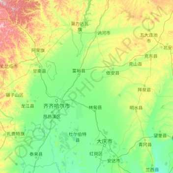
Name: Qiqihar City topographic map, elevation, terrain.

Location: Qiqihar City, Heilongjiang, China (46.22093 122.39236 48.92159 126.66072)

Average elevation: 235 m

Minimum elevation: 121 m

Maximum elevation: 1,088 m

Other topographic maps

Click on a map to view its topography, its elevation and its terrain.

Yangcao

China > Heilongjiang > Anda City

Average elevation: 158 m

Qing'an County

China > Heilongjiang

Average elevation: 260 m

Nangang District

China > Heilongjiang > Harbin

Average elevation: 158 m

Ning'an

China > Heilongjiang > Ning'an City > Chengqu Subdistrict

Average elevation: 357 m

Harbin City

China > Heilongjiang

Harbin, with a total land area of 53,068 km2 (20,490 sq mi), is located in southern Heilongjiang province and is the provincial capital. The prefecture is also located at the southeastern edge of the Songnen Plain, a major part of China's Northeastern Plain. The city center also sits on the southern bank of…

Average elevation: 249 m