
Curaçao topographic map
Interactive map
Click on the map to display elevation.
About this map
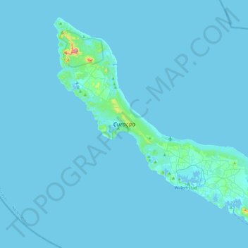
Name: Curaçao topographic map, elevation, terrain.
Location: Curaçao, Nederland (12.03427 -69.16271 12.39273 -68.73664)
Average elevation: 7 m
Minimum elevation: -1 m
Maximum elevation: 322 m
Other topographic maps
Click on a map to view its topography, its elevation and its terrain.
Utrechtse Heuvelrug
Utrechtse Heuvelrug, Utrecht, Nederland
Average elevation: 10 m
Oostappen
Nederland > Noord-Brabant > Ommel
Oostappen, Ommel, Asten, Noord-Brabant, Nederland, 5756 PW, Nederland
Average elevation: 23 m
Driebergen-Rijsenburg
Driebergen-Rijsenburg, Utrechtse Heuvelrug, Utrecht, Nederland
Average elevation: 8 m
Steenwijk
Steenwijk, Steenwijkerland, Overijssel, Nederland
Average elevation: 4 m
Harderwijk
Nederland > Gelderland > Harderwijk
Harderwijk, Gelderland, Nederland
Average elevation: 7 m
Oud-Beijerland
Oud-Beijerland, Hoeksche Waard, Zuid-Holland, Nederland
Average elevation: 0 m
Castricum
Nederland > Noord-Holland > Castricum
Castricum, Noord-Holland, Nederland
Average elevation: 3 m