
Boghni topographic map
Interactive map
Click on the map to display elevation.
About this map
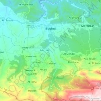
Name: Boghni topographic map, elevation, terrain.
Location: Boghni, Daïra Boghni, Tizi Ouzou, 15003, Algérie (36.45643 3.92416 36.57371 4.01946)
Average elevation: 643 m
Minimum elevation: 180 m
Maximum elevation: 2,085 m
Un ancien fort ottoman situé au nord de la commune. Situé à 500 mètres d'altitude et construit au début du XVIII siècle par le Caïd turc de la Basse Kabylie, Ali Khodja, c'est une des plus importantes forteresses implantées par les Ottomans en Kabylie.
Other topographic maps
Click on a map to view its topography, its elevation and its terrain.
Assi Youcef
Algérie > Tizi Ouzou > Daïra Boghni
Assi Youcef, Daïra Boghni, Tizi Ouzou, 15326, Algérie
Average elevation: 934 m