
Tashkent topographic map
Interactive map
Click on the map to display elevation.
Tashkent
Tashkent features a Mediterranean climate (Köppen: Csa)[46] bordering a humid continental climate (Köppen: Dsa).[46] As a result, Tashkent experiences cold and often snowy winters not typically associated with most Mediterranean climates and long, hot and dry summers. Most precipitation occurs during winter, which frequently falls as snow. The city experiences two peaks of precipitation in the early winter and spring. The slightly unusual precipitation pattern is partially due to its 500 metres (1,600 ft) altitude. Summers are long in Tashkent, usually lasting from May to September. Tashkent can be extremely hot during the months of July and August. The city also sees very little precipitation during the summer, particularly from June through September. [47][48]
About this map
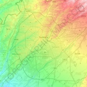
Name: Tashkent topographic map, elevation, terrain.
Location: Tashkent, 100000, Uzbekistan (41.15773 69.12171 41.42250 69.52591)
Average elevation: 441 m
Minimum elevation: 352 m
Maximum elevation: 598 m
Other topographic maps
Click on a map to view its topography, its elevation and its terrain.