
Lydden topographic map
Click on the map to display elevation.
About this map
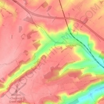
Name: Lydden topographic map, elevation, terrain.
Location: Lydden, Dover, Kent, England, United Kingdom (51.14705 1.19861 51.17242 1.26171)
Average elevation: 116 m
Minimum elevation: 37 m
Maximum elevation: 147 m
Other topographic maps
Click on a map to view its topography, its elevation and its terrain.
St Margaret's Bay
United Kingdom > England > Kent > Dover > St. Margaret's at Cliffe
Average elevation: 38 m
White Cliffs of Dover
United Kingdom > England > Kent > Dover > St. Margaret's at Cliffe
Average elevation: 49 m