
Ford City topographic map
Interactive map
Click on the map to display elevation.
About this map
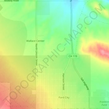
Name: Ford City topographic map, elevation, terrain.
Location: Ford City, Taft, Kern County, California, United States (35.15126 -119.46548 35.18064 -119.44785)
Average elevation: 264 m
Minimum elevation: 219 m
Maximum elevation: 314 m
Ford City is a census-designated place (CDP) in Kern County, California, United States. Ford City is located 1 mile (1.61 km) north of Taft, at an elevation of 892 feet (272 m). The population was 4,348 at the 2020 census, up from 4,278 at the 2010 census. It is immediately north of Taft, between the huge Midway-Sunset Oil Field to the southwest, and the almost exhausted Buena Vista Oil Field to the northeast. State Route 119 passes east of town from its junction with SR 33 to the south.
Other topographic maps
Click on a map to view its topography, its elevation and its terrain.
South Taft
United States > California > Kern County > Taft > South Taft
South Taft, Taft, Kern County, California, United States
Average elevation: 343 m
Taft Heights
United States > California > Kern County > Taft > Taft Heights
Taft Heights, Taft, Kern County, California, United States
Average elevation: 368 m