
Seriana topographic map
Interactive map
Click on the map to display elevation.
About this map
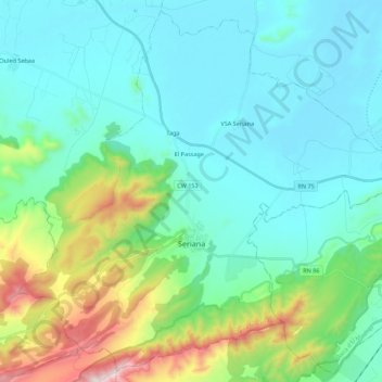
Name: Seriana topographic map, elevation, terrain.
Location: Seriana, Daïra de Seriana, Batna, Algérie (35.63277 6.08527 35.80110 6.30531)
Average elevation: 987 m
Minimum elevation: 798 m
Maximum elevation: 1,724 m
Other topographic maps
Click on a map to view its topography, its elevation and its terrain.
Lazrou
Algérie > Batna > Daïra de Seriana
Lazrou, Daïra de Seriana, Batna, Algérie
Average elevation: 837 m