
El Meridj topographic map
Interactive map
Click on the map to display elevation.
About this map
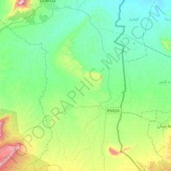
Name: El Meridj topographic map, elevation, terrain.
Location: El Meridj, daïra Ouenza, Tébessa, Algérie (35.70298 8.11126 35.94470 8.27325)
Average elevation: 612 m
Minimum elevation: 427 m
Maximum elevation: 1,217 m
Other topographic maps
Click on a map to view its topography, its elevation and its terrain.
Ouenza
Algérie > Tébessa > daïra Ouenza
Ouenza, daïra Ouenza, Tébessa, 12003, Algérie
Average elevation: 553 m