
Radegast topographic map
Interactive map
Click on the map to display elevation.
About this map
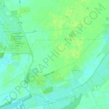
Name: Radegast topographic map, elevation, terrain.
Average elevation: 83 m
Minimum elevation: 77 m
Maximum elevation: 89 m
Other topographic maps
Click on a map to view its topography, its elevation and its terrain.
Prosigk
Deutschland > Sachsen-Anhalt > Südliches Anhalt
Prosigk, Südliches Anhalt, Anhalt-Bitterfeld, Sachsen-Anhalt, 06369, Deutschland
Average elevation: 86 m
Fuhne
Deutschland > Sachsen-Anhalt > Südliches Anhalt
Fuhne, Südliches Anhalt, Anhalt-Bitterfeld, Sachsen-Anhalt, Deutschland
Average elevation: 83 m