
Chong-Alay District topographic map
Interactive map
Click on the map to display elevation.
About this map
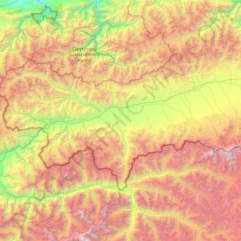
Name: Chong-Alay District topographic map, elevation, terrain.
Location: Chong-Alay District, Osh Region, 723700, Kyrgyzstan (39.17274 71.49894 39.80503 72.92313)
Average elevation: 3,745 m
Minimum elevation: 1,275 m
Maximum elevation: 7,373 m
Other topographic maps
Click on a map to view its topography, its elevation and its terrain.