
District d'Antananarivo Avaradrano topographic map
Interactive map
Click on the map to display elevation.
About this map
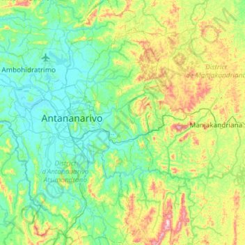
Name: District d'Antananarivo Avaradrano topographic map, elevation, terrain.
Average elevation: 1,371 m
Minimum elevation: 1,241 m
Maximum elevation: 1,796 m
Other topographic maps
Click on a map to view its topography, its elevation and its terrain.
Antananarivo
Antananarivo (Malagasy: [antananaˈrivʷ]; French: Tananarive, pronounced [tananaʁiv]), also known by its colonial shorthand form Tana (pronounced [tana]), is the capital and largest city of Madagascar. The administrative area of the city, known as Antananarivo-Renivohitra ("Antananarivo-Mother Hill" or…
Average elevation: 1,309 m
Antananarivo
Antananarivo (French: Tananarive, pronounced [tananaʁiv]), also known by its colonial shorthand form Tana, is the capital and largest city of Madagascar. The administrative area of the city, known as Antananarivo-Renivohitra ("Antananarivo-Mother Hill" or "Antananarivo-Capital"), is the capital of Analamanga…
Average elevation: 1,309 m