
Thank you for supporting this site ❤️
Make a donation
Make a donation
Vladivostok topographic map
Click on the map to display elevation.
Thank you for supporting this site ❤️
Make a donation
Make a donation
Vladivostok
Vladivostok has a monsoon-influenced humid continental climate (Köppen climate classification Dwb) with warm, humid and rainy summers and cold, dry winters. Owing to the influence of the Siberian High, winters are far colder than a latitude of 43 °N, roughly the same latitude as Milwaukee and Perpignan, should warrant given its low elevation and coastal location, with a January average of −11.9 °C (10.6 °F). Since the maritime influence is strong in summer, Vladivostok has a relatively cold annual climate for its latitude.
Thank you for supporting this site ❤️
Make a donation
Make a donation
About this map
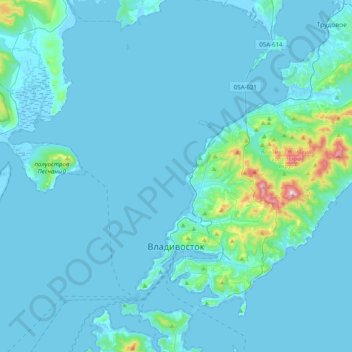
Name: Vladivostok topographic map, elevation, terrain.
Average elevation: 29 m
Minimum elevation: -3 m
Maximum elevation: 450 m
Thank you for supporting this site ❤️
Make a donation
Make a donation