
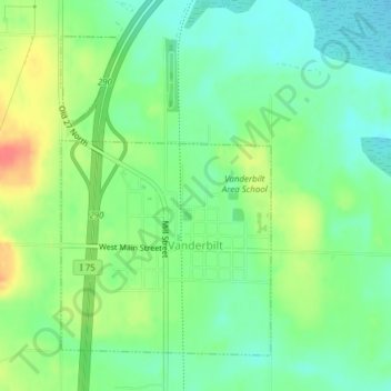
Vanderbilt topographic map
Interactive map
Click on the map to display elevation.
About this map
Name: Vanderbilt topographic map, elevation, terrain.
Average elevation: 334 m
Minimum elevation: 313 m
Maximum elevation: 369 m
Other topographic maps
Click on a map to view its topography, its elevation and its terrain.
Gaylord
United States > Michigan > Otsego County
Gaylord, Otsego County, Michigan, United States
Average elevation: 401 m
Elmira
United States > Michigan > Otsego County
Elmira, Elmira Township, Otsego County, Michigan, 49730, United States
Average elevation: 389 m
Knowlton Lake
United States > Michigan > Otsego County
Knowlton Lake, Bagley Township, Otsego County, Michigan, United States
Average elevation: 399 m
Hayes Township
United States > Michigan > Otsego County
Hayes Township, Otsego County, Michigan, United States
Average elevation: 407 m
Lake Marjory
United States > Michigan > Otsego County
Lake Marjory, Otsego Lake Township, Otsego County, Michigan, United States
Average elevation: 404 m