
Place de la Brèche topographic map
Interactive map
Click on the map to display elevation.
About this map
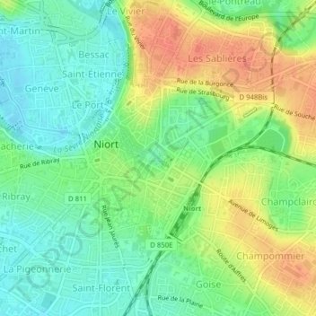
Name: Place de la Brèche topographic map, elevation, terrain.
Average elevation: 30 m
Minimum elevation: 10 m
Maximum elevation: 55 m
Other topographic maps
Click on a map to view its topography, its elevation and its terrain.
Sainte-Pezenne
France > Nouvelle-Aquitaine > Niort
Sainte-Pezenne, Niort, Deux-Sèvres, Nouvelle-Aquitaine, France métropolitaine, 79000, France
Average elevation: 40 m
Tour Chabot Gavacherie
France > Nouvelle-Aquitaine > Niort
Tour Chabot Gavacherie, Niort, Deux-Sèvres, Nouvelle-Aquitaine, France métropolitaine, 79000, France
Average elevation: 22 m
Saint-Florent
France > Nouvelle-Aquitaine > Niort
Saint-Florent, Niort, Deux-Sèvres, Nouvelle-Aquitaine, France métropolitaine, 79000, France
Average elevation: 21 m
Centre Ville
France > Nouvelle-Aquitaine > Niort
Centre Ville, Niort, Deux-Sèvres, Nouvelle-Aquitaine, France métropolitaine, 79000, France
Average elevation: 29 m
Goise Champommier Champclairot
France > Nouvelle-Aquitaine > Niort
Goise Champommier Champclairot, Niort, Deux-Sèvres, Nouvelle-Aquitaine, France métropolitaine, 79000, France
Average elevation: 31 m