
Thank you for supporting this site ❤️
Make a donation
Make a donation
Furadouro topographic map
Click on the map to display elevation.
Thank you for supporting this site ❤️
Make a donation
Make a donation
About this map
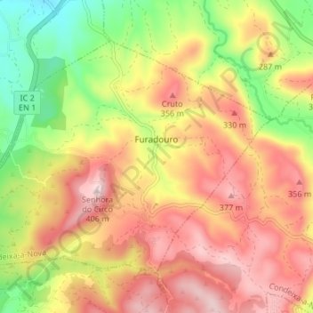
Name: Furadouro topographic map, elevation, terrain.
Location: Furadouro, Condeixa-a-Nova, Coimbra, Portugal (40.04703 -8.53923 40.08504 -8.47236)
Average elevation: 236 m
Minimum elevation: 39 m
Maximum elevation: 405 m
Thank you for supporting this site ❤️
Make a donation
Make a donation
Other topographic maps
Click on a map to view its topography, its elevation and its terrain.