
Cepos topographic map
Interactive map
Click on the map to display elevation.
About this map
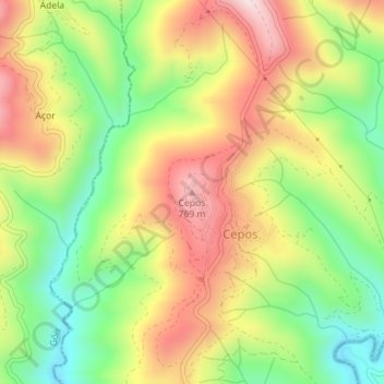
Name: Cepos topographic map, elevation, terrain.
Average elevation: 576 m
Minimum elevation: 365 m
Maximum elevation: 803 m
Other topographic maps
Click on a map to view its topography, its elevation and its terrain.
Paisagem Protegida da Serra do Açor
Portugal > Centro > Cepos e Teixeira
Paisagem Protegida da Serra do Açor, EM 508, Teixeira, Cepos e Teixeira, Arganil, Coimbra, Pinhal Interior Norte, Centro, 3305-031, Portugal
Average elevation: 628 m
Mata da Margaraça
Portugal > Centro > Cepos e Teixeira
Mata da Margaraça, EM 508, Teixeira, Cepos e Teixeira, Arganil, Coimbra, Pinhal Interior Norte, Centro, 3305-031, Portugal
Average elevation: 740 m